Filthy buildings, royal visits and demolished slums – a collection of 30 vintage snapshots of Greater Manchester in the 1960s.

|
| View along Portland Street on the eastern side of Piccadilly Gardens, early 1964. |
 |
| View along Portland Street on the eastern side of Piccadilly Gardens, early 1964. |

|
| ABC Television House on Mount Street, from the junction of Oxford Street and Lower Mosley Street, c. 1960. Designed by J. E. Beardshaw & Partners and built 1959-60. |
 |
| View across St Peters’ Square to the Cenotaph, Library and Town Hall Extension. Taken before the cleaning of the Town Hall in 1965-66. |
 |
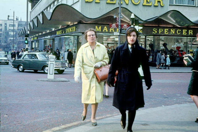
| Shoppers outside the Marks & Spencer store at the junction of Cross Street, Corporation Street and St Mary’s Gate in 1964. |
 |
| View towards Manchester city centre with Grosvenor Square and Oxford Road in the foreground, September 1965. Taken from the roof of the newly-built extension to the Manchester College of Art and Design (Chatham Building). |
 |
| View along Cavendish Street from Oxford Road towards Hulme, mid 1960s. |
 |
| View across Hulme showing areas cleared for redevelopment. Taken from the extension to the Manchester College of Art and Design (the current Chatham Building) around 1966. |
 |
| Terraced houses in Lucknow Grove, Hulme, mid 1960s. |
 |
| Corner shop and terraced housing in Hulme c. 1967. |
 |
| The George Inn on the junction of Radnor Street and Pinder Street, Hulme, left isolated by the demolition of surrounding houses and shops. |
 |
| View along Mosley Street towards Piccadilly from the junction with Princess Street in 1966. The City Art Gallery is on the right, with the Commercial Union Assurance building under construction beyond it. |
 |
| View looking north over the site of the University of Manchester Institute of Science and Technology (UMIST) in the mid 1960s. Taken in the vicinity of Grosvenor Street, Chorlton on Medlock, before the construction of the Mancunian Way and the Brunswick housing estate. |
 |
| Entrance to the John Dalton College of Technology on Chester Street, late 1960s. |
 |
| The elevated section of the Mancunian Way and adjoining slip road at All Saints, c. 1968. Taken from the Cavendish School on Loxford Street looking west towards north Hulme. The space in the foreground was subsequently occupied by the Loxford Tower (completed in 1974), and is now the site of the new MMU Business School. |
 |
| View along Boundary Street West towards Oxford Road, during the construction of the extension to the Manchester College of Art and Design, February 1964. On the left is the Cavendish Street Chapel School, which was demolished in 1974 to make way for the Cavendish Building. |
 |
| The newly-built extension to Manchester College of Art and Design (now MMU’ s Chatham Building) in 1966. The site in the foreground is now occupied by the Royal Northern College of Music (i.e. Rosamond Street West runs from left to right). |
 |
| The Plymouth Grove Hotel at the junction of Plymouth Grove and Shakespeare Street, around 1969. |
 |
| The Manchester City Art Gallery at the junction of Mosley Street and Princess Street, photographed in the early 1960s. Designed by Charles Barry as the Royal Manchester Institution and built 1829-36. |
 |
| The warehouse of James Brown & Son at the corner of Portland Street and Aytoun Street, photographed in the 1960s. Now part of the Portland Hotel, the building was designed by Edward Walters and built in 1851-52. |
 |
| Diesel trains on platforms 5 and 6 at Manchester Central Station in the mid-1960s. |
 |
| View of the train shed from the goods entrance at Manchester Central Station in the mid-1960s. |
 |
| The concourse at Manchester Central Station in the mid-1960s. |
 |
| A British European Airways (BEA) plane on the apron at Ringway (Manchester) Airport in 1964. |
 |
| View along Radnor Street, Hulme, near the junction with Fenwick Street, around 1967. Photographed at the time when most of the area had been cleared for wholesale redevelopment, All the buildings in the middle ground, including the Raglan Hotel (on the right) were subsequently demolished to make way for the extensive housing scheme of the late 1960s and early 70s. St Mary’s church on the left of the picture is still standing. |
 |
| View over Hulme looking south west towards St Mary’s church around 1967, showing the extensive area cleared in readiness for redevelopment. The then newly built South Hulme High School (later Birley High School) can be seen to the right of the church. |
 |
| Crowborough Street near the junction with Ridley Grove, in the Hulme/Greenheys district of Manchester, photographed around 1967. |
 |
| A group of five ‘K6’ public telephone boxes at the edge Piccadilly Gardens, Manchester, around 1969. |
 |
| Open ground near the junction of Fenwick Street and Moss Lane East, photographed around 1967 shortly before the redevelopment of Hulme. Moss Lane East runs left to right across the top of the picture, in front of the Moss Side Post Office to the left. The Baptist Church is visible beyond the grey van, which is parked on Lingard Street. |
 |
| Unidentified street in Hulme, photographed around 1967 shortly before the redevelopment of the area. |
(Photos via Manchester Metropolitan University Visual Resources)
